Daintree Map & Location
Situated 100km northwest of Cairns, the Daintree Rainforest location is just over 1,500km northwest of Brisbane and is a vast region of rainforest and tropical wilderness in Far North Queensland. Covering an area of approximately 12,000km2 this Daintree Rainforest map shows how the Daintree National Park is separated by an agricultural area, forming two sections that also include the towns of Mossman and Daintree Village, home to a residential community of over 500 people.
Part of the Wet Tropics of Queensland, the Daintree National Park was founded in 1981 and in 1988, became a World Heritage Site. The world's largest continuous tropical rainforest, the Daintree is also the biggest rainforest on the continent of Australia and includes the Daintree National Park as well as areas of State Forest and privately owned land. The Daintree Rainforest location is famously unique as it grows right down to the edge of the Coral Sea and is often referred to as where the 'reef meets the rainforest'.
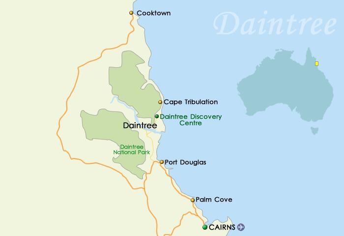
Use a Daintree Rainforest map to find various areas of importance within the rainforest including the Daintree National Park, Daintree Discovery Centre and the Daintree Important Bird Area. Covering 2,656km2 this tract of land coincides with the northernmost part of the World Heritage listed Wet Tropics of Queensland and encompasses Cedar Bay, Black Mountain, Daintree, Mowbray and Mount Windsor National Parks.
Classified as an Important Bird Area by BirdLife International, the tract of land his home to a population of the endangered species the Southern Cassowary. The area is also home to a number of other rare species found only in the Daintree including Golden and Tooth-billed Bowerbirds, Macleay's, Lovely Fairywrens, Atherton Scrubwrens, Chowchillas, Mountain Thornbills, Pied Monarchs, Pale-Yellow Robins, Fernwrens, Victoria's Rifelbirds, Bower's Shrike-Thrushes and Yellow-spotted, Bridled and White-Streaked Honeyeaters.